In 2016, the demand for seismic services was low and the established players were laying up vessels, restructuring and fighting to survive the worst market conditions the industry had ever experienced. While other companies struggled to reduce costs to meet the rigours of the extended downturn, the newly formed Shearwater brought together an experienced management team to forge a lean organisation with four modern high-capacity vessels, proprietary data processing and imaging soft ware and two solid backers in the form of GC Rieber and RASMUSSENGRUPPEN AS.
Towed streamer acquisition
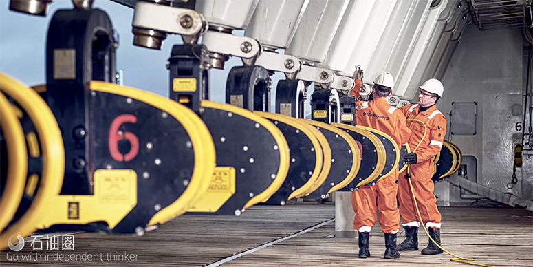
The Qmarine point-receiver marine seismic system was launched in 2000. Comprising a gel filled solid streamer, all in-sea components such as acoustic positioning and streamer control devices are integral to the streamer, which reduces noise and drag. It uses single-sensor recording to record noise with suff icient resolution to enable it to be removed using targeted digital filtering techniques without aff ecting the signal bandwidth or fidelity. The Qmarine system also pioneered steerable streamers by introducing the QFin marine seismic streamer steering system. The QFin system’s remote-controlled wings are designed to reduce noise and enable both precise depth control and horizontal steering. Horizontal streamer steering provides feather correction, safe streamer separation control, fan-mode shooting, and active steering for optimal coverage. Later refinements included steerable sources and the QPilot control system, which integrates all of the streamer command and control functions to optimise 4D repeatability.
Isometric seismic technology
Isometrix is a marine isometric seismic technology that records additional measurements to build a detailed picture of the seismic wavefield in all directions, filling the gaps between the streamers associated with other conventional towed-streamer acquisition technology. This translates directly to a fine-scale resolution of the subsurface in all directions, enabling a more accurate representation of the subsurface geology. An additional benefit of the system is that subsurface coverage can be increased by towing fewer streamers spaced further apart without compromising data quality.
At the core of this technology is a seismic streamer that combines standard hydrophone (P) measurements with those from two accelerometer sensors recording the seismic pressure gradient in the vertical (Z) and crossline (Y) directions. Dual sensor (PZ) measurements enable receiver deghosting, but Isometrix combines the three PZY measurements to perform 3D deghosting and reconstruction of the seismic wavefield between the streamers. This provides true broadband product in all three directions; vertically, along the streamer and crossline between the streamers.
With powerful data preconditioning and noise attenuation enabled by densely spaced sensors, coupled with single-sensor digital processing that is performed in real time in the acquisition system, high-quality field data is produced that is ready for further processing and imaging.
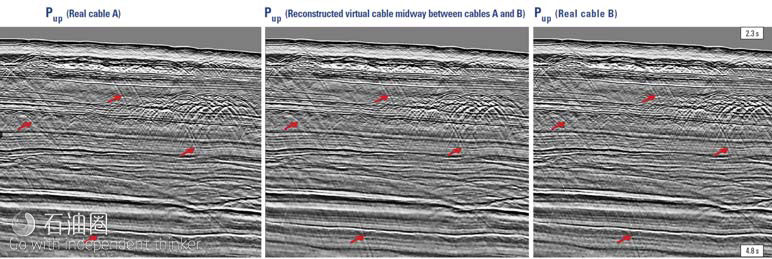
The quality of these measurements enables joint interpolation and 3D deghosting. The example from deepwater frontier exploration acreage off shore east Africa (Figure 1) shows the upgoing seismic wavefield on the left is successfully reconstructed at two neighbouring real streamers as well as at a virtual streamer midway between the two.
These sections already display the characteristics of high quality broadband data, even before deghosting and debubble routines are applied. Complex events such as diff ractions (as indicated) are correctly captured at the virtual streamer midway between the real streamers A and B, despite the 100 m streamer separation, demonstrating the ability of the Isometrix technology to accurately interpolate in the shot domain early in the processing flow.
Ocean bottom seismic
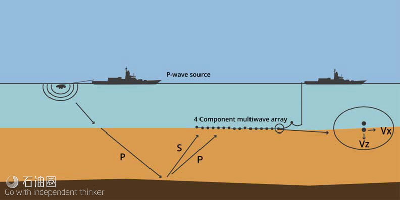
Ocean bottom seismic (OBS) acquisition is a rapidly growing area of the seismic market, comprising ocean-bottom node (OBN) and ocean-bottom cable (OBC) approaches, both of which entail deploying seismic sensors directly on the seabed (Figure 2). Shearwater off ers seabed solutions for a range of environments and water depths, including the Q-Seabed multicomponent OBC system and nodal options, or a combination of both techniques.
Hybrid combinations of both towed-streamer and OBS acquisition are oft en also used for areas where the geology, environment or local oilfield infrastructure do not allow optimal coverage using a single technique or technology. This approach is provided by the company’s three multipurpose seismic vessels.
Qseabed is a single-sensor acquisition system with fully calibrated hydrophones and three-component accelerometers. With the ability to record from up to four cables simultaneously, each with a maximum active length of 30 km and a depth rating of 1500 m, and multi-vessel operations to enable rolling spreads, the system allows for flexible survey design options that improve eff iciency while maximising fold.
Having acquired high quality raw seismic data, advanced data processing and imaging is performed with the Reveal seismic data analysis system.
Data analysis
Reveal processing and imaging soft ware performs time and depth processing and imaging of marine and land seismic data within a single user interface (Figure 3). This full processing platform is designed to run on laptops in the field, in the company’s own large data centres or in those of its clients. With its advanced batch job management, parallel processing and cluster scalability, geophysicists can achieve rapid turnarounds. Data can be read directly from field tapes, SEGYs or other formats and processed wherever there is connectivity. Reveal also provides a developers’ environment for clients keen to integrate it with their own soft ware, workflows and processing systems.
The system’s marine processing modules off er a range of tools for any marine seismic processing task. This starts with the option to perform real time QC onboard a seismic vessel, 2D and 3D surface related multiple elimination (SRME), pre-stack time migration (PSTM) and advanced depth imaging.
Similarly, the land processing tools cover all aspects of land processing from refraction statics to final time and depth imaging from datum. These computer intensive land tools are message passing interface (MPI) enabled, which means computing solutions that were once constrained to a single machine can be divided across a whole cluster. In addition, the system’s advanced land functionality includes the latest algorithms such as 5D interpolation, 3D de-noise and automatic shot re-location.
Reveal’s depth processing tools comprise model building, Kirchhoff PSDM, reverse time migration (RTM), tomography and full waveform inversion (FWI).
Kirchhoff PSDM
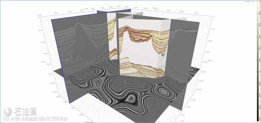
The model building algorithms allow velocity models to be tied to well measurements, horizons manipulated and geobodies visualised (Figure 4). Reveal’s Kirchhoff PSDM is a true amplitude anisotropic migration that uses wavefront reconstruction travel times selected by user driven criteria such as first arrival or minimum velocity contrast. It is ideally suited to moderately complex geology with strong lateral velocity changes.
RTM
Reveal’s RTM is its most advanced depth imaging algorithm. It can perform illumination studies, create angle gathers, filter artifacts and model wavefields (Figure 5). It is well suited for areas where the geology has rapid or sudden lateral changes in velocity that cause significant distortion of the wavefield, and its use of the two-way wave equation allows clear imaging below even the most complex overburdens. It also incorporates a RTM runtime calculator to estimate compute needs.
The tomography tool provides grid-based reflection tomography with automatic and interactive picking methods, together with the ability to estimate anisotropic parameters and Q, the quality factor used to characterise the attenuation of seismic waves in the subsurface.
FWI
FWI is an iterative tomographic technique driven directly by diff erences between true seismic data and synthetic data derived from an estimated earth model (Figure 6). All modelling is performed using the two-way wave equation which leads to a much greater resolution in the inverted model compared that achieved with conventional ray-based tomographic algorithms.
Reveal’s FWI is fully integrated within its platform enabling easy incorporation into larger model-building workflows. For example, intermediate output models can be easily used to test for gather flattening as the inversion proceeds.
Flexibility
Reveal can also be provided on a license basis for use within other development environments. The Python, C++ and Java application program interface (API) gives users the flexibility to develop and incorporate their own algorithms within Reveal and to run their own code eff iciently.
The system has been designed and built entirely in the 21st century for a new wave of young professional geoscientists and developers who demand state-of-the-art soft ware with powerful tools, an intuitive user interface and instant results. It is constantly evolving to allow geoscientists to make faster and more accurate decisions.
Conclusion
Despite the deepest and most prolonged downturn the seismic sector has ever experienced it is clear that the industry has kept research and innovation alive. It has done this by adapting to a diminished business environment in such a way that has enabled technology development to stay ahead of the ever-growing demands of its exploration and production (E&P) customers.
Seismic contractors re-focussing their businesses around their individual core strengths, significant re-structuring and consolidation have all played a part. But perhaps the biggest factor behind the seismic industry’s continuing ability to develop products to improve oil recovery and to image ever more complex geological structures will be the ability to innovate collaboratively. The E&Ps who obtain the most value from their seismic investments will be those who collaborate with vendors to generate new technology.

 石油圈
石油圈


