In 2017, the big news in the logging and formation evaluation industry was the completion in July of the successful merger of Baker Hughes and GE Oil & Gas to form BHGE, which comes on the heels of the unsuccessful effort by Halliburton to purchase Baker Hughes in 2016.
In 2017, the big news in the logging and formation evaluation industry was the completion in July of the successful merger of Baker Hughes and GE Oil & Gas to form BHGE, which comes on the heels of the unsuccessful effort by Halliburton to purchase Baker Hughes in 2016.
Several notable texts and reference books on logging and petrophysics, as well as significant review papers on a variety of topics, have been published recently. These include porosity, pore structure characterization in tight sandstones, quantitative image analysis, laboratory measurement of low-permeability unconventional gas reservoirs, and permeability standards for tight rocks.
Depth measurement
Depth is the fundamental and critical measurement that ties all downhole data together, yet the best methods for ensuring accurate depth measurements in all borehole conditions and at all well inclinations, are still evolving. Several recent papers discuss best approaches/practices for obtaining the most accurate depth measurement in wireline and LWD operations, where wireline stretch and thermal elongation of pipe may significantly impact the accuracy of the depth measurement.
LOGGING-WHILE-DRILLING
Wellbore position/survey accuracy. This is another topic that is continually evolving. As discussed previously, obtaining accurate MWD surveys in high latitudes (e.g., Barents Sea) is difficult, due to time-dependent variations in Earth’s magnetic field. The magnetometers and accelerometers used in MWD tools are affected by Earth’s magnetic field, which changes with location—the main magnetic field increases in intensity and inclination toward the magnetic poles—and also over time. Magnetic-field corrections are based on the fundamental earth geomagnetic model used.
Baker Hughes recently introduced the CHAOS-X geomagnetic reference model to provide high-resolution global vector magnetic field estimates of earth’s magnetic field, to improve the precision of magnetic directional surveys. Several new correction methods to improve survey accuracy and wellbore positioning have been proposed. Accurate well positioning is particularly important in well collision avoidance and for electromagnetic ranging techniques used to intercept wells.
Microsensor logging systems are miniature self-contained measurement devices developed to provide cost-effective, near-real-time distributed measurements of downhole parameters, such as temperature and pressure, along the length of the borehole. Microsensors are introduced into the drilling fluid by different methods but return to the surface in the circulating fluid and are trapped at the shale shakers. Two concepts have been discussed, one of which has undergone field tests. These while-drilling “logging” systems consist of (1) high-precision temperature or pressure sensors in integrated circuits on a microchip that also includes microprocessor, memory, transmitter and receiver circuits, and a rechargeable battery, and (2) a surface data collection device and an initiator.
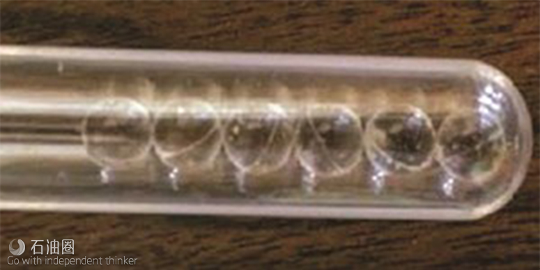
In one system, developed initially as a student thesis at the University of Tulsa, the sensors are approximately 7.5 mm in diameter, encapsulated in a spherical protective shell (Fig. 1), and have accuracies of ±60 psi and ±1.8°F, respectively. The sensors are introduced into the drilling fluid, using either a tracer injection system or by dropping them into the drill pipe during a connection and then travel through the drill pipe, out the bit nozzle, and back up the annulus to surface as the mud circulates.
The logging measurements are recorded sequentially with a timestamp, and the measurement depth is calculated using the timestamp and mud flowrate. When the sensors reach the surface, a device communicates wirelessly with the microchip to download the stored data and reset the circuit for another trip. Potential applications for these microchip sensors include optimizing cementing evaluation and locating fluid-loss zones.
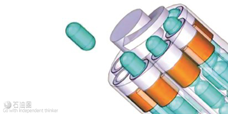
In the Sintef Digital microsonde (µSonde) system, which is still in the conceptual stage, microsensors contained in capsules are released at the bottom of a well, and record downhole parameters as fluid circulation brings them to surface. In drilling wells, the µSonde storage magazine (Fig. 2) is deployed together with the bottomhole assembly, whereas in production wells, a storage magazine carrying the microsondes is deployed to the bottom of the well at any time during the life of the well. The sondes are released, based on predetermined well conditions and/or time intervals and activated at launch. They continuously record measurements to memory, and at surface, the recorded data are transferred wirelessly for analysis.
Measurement depth is estimated from a combination of the elapsed time until capture, analysis of the accelerometer data, and well features recognized by analyzing the different measurements. The effective density of the sondes can be matched to the well fluid, and sondes using other sensor types (e.g., acoustic, three-axis accelerometer/gyro/magnetometers) could be constructed to meet different needs. Applications might include well integrity analysis, hole cleaning, borehole instability and lost-circulation zones.
HPHT triple-combo
Weatherford introduced a new HPHT LWD service (HeatWave Extreme, HEX) for wells encountering extreme bottomhole temperatures and pressures. The LWD triple-combo service was developed jointly with Chevron specifically for use in the Gulf of Thailand. The service, which was developed in two phases, employs completely redesigned components (including electronics and sensors) that have eliminated the need for cooling trips during extended runs at high BHT. The triple-combo service includes gamma ray, compensated dual-frequency resistivity, thermal neutron-porosity and density measurements.
The resistivity tool has two transmitters and three receivers (20-, 30-, and 46-in. spacing) and operates between 200 kHz and 2 MHz. A conventional Am-Be chemical source is used for the density measurement. The MWD system provides borehole azimuth and inclination, and borehole and annular pressure (for ECD determination). The service is rated for up to 200 hr of operation at 392°F and 30,000 psi.
Borehole imaging
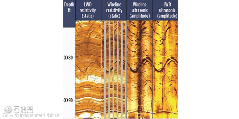
Baker Hughes has tested a new high-resolution-while-drilling ultrasonic pulse-echo borehole-imaging tool for use in all borehole fluids. New transducers were designed to achieve an adequate signal in difficult borehole conditions, (e.g., heavy OBM and soft formation or rough surfaces with low reflectivity) and provide wide bandwidth to provide accurate time-domain response. The tool sampling rate is sufficient to fully sample the borehole in the typical rates of penetration (200 ft/hr) and rpm (80 to 180) ranges experienced while drilling. Figure 3 compares images from the new tool with those from wireline imaging devices. The initial tool was implemented in a 6¾-in. collar and is rated to 329°F.

 石油圈
石油圈


