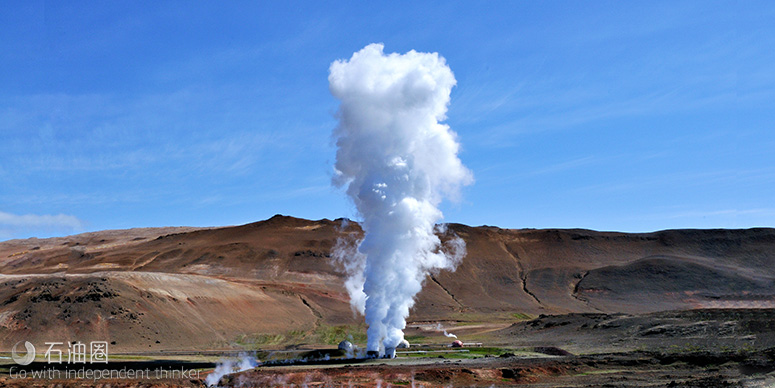
地热资源可广泛用于地热发电、采暖、温室、养殖、康复医疗、提取化工原料、旅游以及瓶装矿泉水等方面。因此,近年来地热资源勘探活动十分活跃,而震电勘探技术作为一种寻找地热带的方法也广受关注。
来自 | Seismo Electronics
编译 | 白矾
震电勘探技术是利用电动电位的方法的物探技术,它是利用流体的可动性直接勘探地下流体包括(水,油和天然气)的新技术,具有定位精度高,成本低,和操作程序简单的特点。
传统的地震勘探和电法勘探是分别根据不同的地震波波速或者电阻率,间接找到水层或油气层的位置。与它们不同,震电法能够同时接收同一震源产生的地震信号和震电信号,然后根据流体的物理特性,直接确定流体的深度,并估算流量。因此,震电勘探不仅可以和传统勘探方法一样,勘探地下流体资源,更适用于寻找一些地质情况复杂、无法用传统勘探方法找到地下流体层,如地热资源勘探、裂隙带找水、页岩气和页岩油的压裂监测等非常规性勘探。
地热能是由地壳抽取的天然热能,这种能量来自地球内部的熔岩,并以热力形式存在。地热能是一种新的清洁能源,当今,人们的环保意识日渐增强,能源也日趋紧缺,对地热资源的合理开发利用已愈来愈受到人们的青睐,所以寻找一种适用于地热能勘探的技术就显得尤为重要。
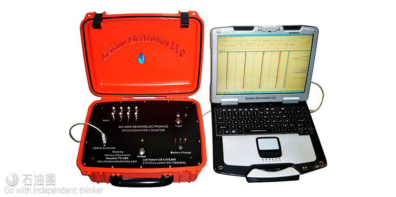
震电勘探方法不仅克服许多传统物探方法的缺点,例如地震勘探复杂的检波器排列与高成本,同时具有比高密度电法勘探和重磁勘探更高的精度优势。同时,震电检测方法利用对薄水层的敏感性,能准确探测水层的顶底界面位置和平面分布范围,因此,将成为适用于勘探地热水的常规方法。而美中地龙震电有限公司(Seismo Electronics)推出的DC-4500震电地下流体定位仪就是一款先进的震电勘探产品。
DC-4500震电流体勘探仪能够有效避免干井,能够在实时分辨其是水层还是油气储层。采用相关应用,可以找出各种流体的地下位置,比如原油和地下水、地下水和含盐卤水还可以与地震勘探结合使用。
震电勘探原理
所谓震电效应,就是大地孔隙介质中弹性波场与电磁场之间相互作用引起大地介质中这两种地球物理场特性发生变化的物理效应。在地球物理勘探理论中,震电效应则特指在弹性波场作用下大地电磁场特性发生变化。
地下含流体孔隙介质中产生的震电信号较强主要是由于在孔隙介质的固-液交界面上存在双电层现象。在初始平衡状态下,岩石颗粒表面通常吸附负离子,在其周围溶液的界面上则分布正离子,这样便在固-液间形成了双电层。当地震波在地下含流体饱和孔隙介质中传播时,带电液体和骨架会产生非同相振动,引起孔隙流体与固体骨架的相对运动,导致电荷密度发生波动,从而使孔隙流体中的带电离子形成微电流并在不连续边界处将会激发电磁波。通过接收这种电磁波,地下流体定位仪可以直接定位地下流体层的位置和深度,即使在勘探难度较大的裂隙带,也可以准确找到地下流体层的位置。
震电效应的幅度与流体在多孔介质的孔隙度成正比,因而有可能通过震电效应信号幅值的大小直接探测含油气地层孔隙度的相对大小。
震电勘探流程
一套震电勘探设备包括震源,接收信号的传感器和接收机。美中地龙震电公司通常使用的震源是水牛枪,接收信号的传感器为4根高稳定的极化电极和2个地震检波器。接收机为其自主研发的DC-4500震电地下流体定位仪。定位仪有4道,其中1道和4道接收地震波信号;而2道和3道与不极化电极相连接,接收震电信号。在野外操作时,震源最先产生地震波,当地震波在地下传播遇到地下流体层时,会引起地下流体层内的流体产生震动,从而产生相关的电信号。电信号反向传播回地面后,就会被震电地下流体定位仪接收,进而确定地下流体层的地表位置。最终经过处理和解释,美中地龙震电公司可以进一步确定地下流体层的深度和体积。
DC-4500震电流体勘探仪

一套DC-4500震电流体定位仪的震电记录设备由震电信号预调节器和军用级内置GPS的电脑端组成。在勘探中,设备可以同时获取地震信号和相伴随的震电信号。
地震源
人工地震源是地震和震电勘察的关键。震电法的勘探深度依赖于震源,美中地龙震电公司可以接收到来自于地下7000英尺深的信号,使用特殊震源,甚至可以接收到深度达到30000英尺深的信号。可用震源包括:大锤,水牛枪和重锤震源。
大锤
浅层地震折射常使用的震源,勘测深度有限。
声纳震源激发器
“声纳震源激发器”(水牛枪)作为人工震源,具有携带方便,价格低廉的优点,美中地龙震电公司已在现场作为主要地震源推广使用。水牛枪的主要问题是其爆炸声音响亮,人口密集的地区可能会限制其使用。美中地龙震电公司已经开发了专业的消声设备,安装在水牛枪内部,使其使用12号猎枪子弹具有相同的地震效果。
重锤震源
由于一些作业者的特别需求,美中地龙震电公司还测试过采用重锤激发的地震勘探。测试数据表明一个200P/S的落锤可以产生与12号子弹同样的声波信号。只是落锤震源要比水牛枪震源的成本高。
美国德克萨斯州中石化地热勘探试验项目
2014年4月,美中地龙震电公司与中国石化石油勘探开发研究院合作,在美国德克萨斯州休斯顿市南部运用震电技术勘探地热资源,取得了良好的效果。
此次震电勘探地热资源试验靶区正处于埤里三特河地区(Pleasant Bayou),此区的地热来源地层属于安得劳期(Andrau)福来欧层(Frio Formation)。奥陶纪的福来欧层包含富含砂岩的河相至三角洲相的堆积系统,是墨西哥湾沿岸的第三纪的重要油气天然资源的储存层。福来欧层的厚度大约可从300米至3000米厚。
美中地龙震电公司选择了离德州地热实验井附近的农场作为试验靶区。靶区位于休士顿市的南部,呈矩形。美中地龙震电公司共设计了两条震电勘探测线,分别位于靶区的西侧和北侧边界,共含有34个震电勘探测点。
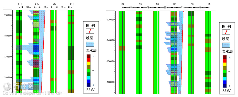
美中地龙震电公司根据两条震电测线以及经过断层的相关情况,分别在两条测线上共做了四个剖面:AA’、BB’、CC’和DD’。结合地质信息,该公司将在剖面上对数据信息进行分析比较,计算出水层的深度和厚度。

剖面DD’显示在测点L12和L13之间存在着断层。此断层两侧都是由致密页岩层在断层附近垂直方向上形成的破碎带。通过比较L12~L13震电含水指数条纹图和R5~R8震电含水指数条纹图(SEW),美中地龙震电公司推断L12和L13之间的破碎带要比R5~-R8之间的破碎带要宽一些,因而含水量更多。如果在这里打井,出水量可能会比在R5~R8之间的破碎带要多,这还需要进一步勘查。如果这两条裂隙断层来自于同一个水源,渗透率大的断层会比渗透率小的断层出更多的水。地下的高温水可以沿着这个垂直的破碎带流到浅层。在浅层的这个位置钻井,就会得到高温的地下水。
剖面图AA’显示了从R4到L16个连续的测点数据。在测点R5和R8之间存在着断层。断层的两侧原来都是由致密页岩在断层附近垂直的方向形成破碎带。地下的高温水可以沿着这个垂直的破碎带流到浅层。在浅层的这个位置钻井,就会得到高温地下水。

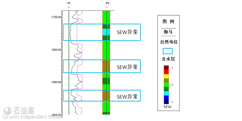
通过比较震电含水指数条纹图Seismo Electric Water(SEW)与测井曲线,可以发现自然电位曲线和伽马曲线所显示的含水层的位置,70%到80%的震电含水指数条纹图(SEW)也有相应的异常反应。这表示震电含水指数条纹图(SEW)找水的功能的成功率最少是70%~80%。中石化评审专家组对美中地龙震电公司的项目给予了高度评价。
An seismic wave generated electrokinetic potential method and geophysical technology for directly locating groundwater aquifers to deduce the associated petroleum hydrocarbon reservoir structure with high accuracy, low cost, site access , portability, and simple operational procedures in the field.
The seismoelectric method is different from conventional seismic prospecting or an electrical resistivity survey, which separately register either a seismic impulse velocity or electrical resistivity sounding data in the geological structure. Seismoelectric make use of the different physical character between the ground-flow(water and oil) from the earth solid (rock or soil) to locate ground-flow directly.
DC-4500 Seismoelectric Ground-Flow Locator receives both a seismic signal and a seismoelectric signal generated by the same seismic source. The penetration of seismoelectric signal is depend on the power of seismic source. We have got 7000 feet depth reservoir seismoelectric data in LA with a Buffalo gun seismic source. We also have seismoelectric data from 30000 feet depth with a special testing.
DC-4500 Seismoelectric survey can avoid dry holes in water well drilling, indicates groundwater in real time analysis. With further data processing and interpretation with the reference application to locate such fluids- crude oil or natural gas.
Seismoelectric survey can also work with seismic survey. With the same seismic source, we can get both seismic data and seismoelectric data at same time give additional ground-flow information to the seismic survey, with lower cost. To indicate groundwater, seismoelectric signal is around 70% match the well log nearby.
Seismoelectric Survey Principle
Seismoelectric effect is associated with charge activities taking place at the mineral-water interface,defined as the electrical double layer (EDL). When a seismic wave passes through a porous rock, it agitates movements of both the rock frame and the pore fluid, not at the same rate. Relative movement between fluid and solid particles disturbs the electrical double layer, which in turn produces electric charge movement. Eventually the variation in electric charge creates an electric potential signal, which can be detected as a seismoelectric signal.
Seismoelectric (SE) survey method is a technology based on the seismoelectric effect. It measures the electric potential signal at ground surface with a seismic source for detecting subsurface water properties. This potential is a function of rock porosity, permeability, fluid contents and their saturation.
Superior to Seismic Reflection method, seismoelectric signals could be screened by proper arrangement of surface probes for vertical transmission. Hence it can reduce the influence of noise from diffraction and out of plane reflection commonly associate with seismic reflection method. Furthermore, since seismoelectric signals are related to fluid properties, the SE method could provide additional parameters for petrophysical properties.
SE signals are sensitive to the permeability of the rocks, therefore SE survey has served as a valueadding tool for the underground aquifer detection for the last five years by Seismo Electronics LLC. in many areas of the world. The principles of seismoelectric water value color strips (SEW) interpretation are shown in the figure below.
SE Surveying Method Vs. Other Traditional Surveying Methods
Seismoelectric (SE) survey method is a technology based on the seismoelectric effect. It measures the electric potential signal at ground surface with a seismic source for detecting subsurface hydrocarbon reservoir. This potential is a function of rock porosity, permeability, fluid contents and their saturation. The successful rate for SE survey in oil reservoir detection is higher than 50%. Seismoelectric (SE) survey can also work with seismic survey. To use the same seismic source, we can get both seismic data and seismoelectric data at same time. The seismoelectric signal work as pseduo-well log to be projected to the seismic section to give additional ground-flow information to the seismic survey, with lower cost.
Seismoelectric (SE) survey also can detect the hydrocarbon reservoir below the salt dome. In some area, the salt layers sometimes covered reservoir, and the seismic wave is difficult reflected back to the surface. Therefore, it is extremely difficulty for traditional seismic surveying method to detect the hydrocarbon reservoir below the salt. However, salt is a good conductor, hence seismoelectric signals can identify the potential hydrocarbon reservoir below the salt.
One set of survey equipment includes signal receivers, one data collector and seismic source. We use two geophones and four electrodes as signal receivers, one Seismoelectric Ground-Flow DC-4500 Locator as a SE data collector, and Buffalo Gun as seismic source. DC-4500 locators have total 4 channels. Channels 1 and 4 are used to connect with 2 geophones: one is placed 5 meters away and the other is 20 meters away. These two channels are in charge to receive the seismic signals. Channels 2 and 3, connecting with two pairs of electrodes spaced with one meter along a line, record the seismoelectric signals. When a seismic wave produced by a seismic source passes through a porous rock, it agitates movements of both the rock frame and the pore fluid, not at the same rate. Relative movement in turn generates an electric potential signal, which can be detected as a seismoelectric signal. After further data processing and interpretation, we can detect the depth location of the hydrocarbon reservoirs and estimate the r volume.
With some special requirements of our clients, we have also tested a weight drop seismic source methodology of generation in the seismoelectric survey. The tested data shown that one drop energy of A200 P/S Hammer is similar to a 2.5 inch 12 gauge cartridge acoustic impulse. However, the relative cost of this weight drop seismic source is much higher than using a buffalo gun.
未经允许,不得转载本站任何文章:
-

- 白矾
-
石油圈认证作者
- 毕业于中国石油大学(华东),油气井工程硕士,长期聚焦国内外石油行业前沿技术装备信息,具有数十万字技术文献翻译经验。


 石油圈
石油圈


